
2 hours ago
Keeping an eye off the Carolina coast this week
Over the weekend the National Hurricane Center added to its tropical outlook the system off the southeast U.S. we began discussing in this newsletter last Thursday.
2 hours ago
Over the weekend the National Hurricane Center added to its tropical outlook the system off the southeast U.S. we began discussing in this newsletter last Thursday.

5 hours ago
A brush fire is burning in west Broward County Sunday evening.

2 days ago
A possible area of development is being monitored off the southeastern coast for next week.

2 days ago
Despite impactful flooding last week across the central Gulf Coast from the remnants of short-lived Tropical Storm Arthur — rainfall totals topping two feet in some places, bringing rainfall totals since May to nearly 50 inches across parts of southern Louisiana and Mississippi — it’s been largely crickets across the Atlantic since the start of the 2026 Atlantic hurricane season.

As June transitions to July next week, we’ll be keeping an eye off the shores of the southeast U.S. for an elongated area of low pressure tied to a stalled frontal zone that could spawn an area to watch by the middle to latter part of next week.

It’s the time of year giant plumes of dust heaved off the African continent from the Sahara Desert travel thousands of miles across the Atlantic, sprinkling down on the shoreline sands of Florida and the U.S. Gulf Coast.

The 2025 hurricane season was a coming-of-age story for AI weather models, which have been around in some capacity since around 2022.

June is historically the least active month of the hurricane season, but that doesn’t mean the first month of the season can’t bring its fair share of issues.

Tropical Storm Arthur lasted only 12 hours as a named storm on Wednesday – one of the shortest-lived named storms in Atlantic basin records – but its stormy, water-logged remnants dragged a slug of torrential rains and severe weather through parts of the Deep South on Thursday, leading to widespread, devastating flooding from south and central Louisiana to southeastern Mississippi and lower Alabama.

Short-lived Tropical Storm Arthur – which formed late Wednesday morning along the middle Texas coast – moved inland near Galveston by Wednesday afternoon and lost its tropical designation by Wednesday evening as its circulation quickly unraveled.

Two large brush fires burning in Miami-Dade have blanketed parts of South Florida in smoke, driving down air quality and affecting communities across the region.

The National Hurricane Center late Wednesday morning upgraded Potential Tropical Cyclone One to Tropical Storm Arthur, the first named storm of the 2026 Atlantic hurricane season.

A large tropical disturbance spinning inland over the mountains of northern Mexico – in part the remnants of once-Tropical Storm Cristina that crossed Central America late last week and now dubbed Invest 90L by the National Hurricane Center, the first Invest of the 2026 Atlantic hurricane season – is expected to briefly re-emerge over the coastal waters off Texas late Tuesday and Wednesday where odds are increasing it could make a brief run as the season’s first tropical storm.

A tropical disturbance that moved into northern Mexico over the weekend – partly the leftover spin of once-Tropical-Storm Cristina that crossed Central America from the eastern Pacific – will hitch a ride along an unusually strong and slow-moving cold front this week through the Deep South.

The disturbance that we began previewing in this newsletter over a week ago and that was first mentioned by NHC on Wednesday is now centered over the Bay of Campeche in the extreme southern Gulf.

On Wednesday, the team of hurricane experts at Colorado State University (CSU) issued their June forecast update for the 2026 Atlantic hurricane season, reducing their predictions from their earlier April outlook, and now calls for the lowest tropical activity seen across the basin since 2015.

A disturbance we first detailed in this newsletter a week ago is now being tagged by the National Hurricane for low development odds later this week in the southern reaches of the Gulf before moving inland over eastern Mexico late Saturday into Sunday.

A rare magnitude 6.1 earthquake near western Cuba that was felt across parts of Florida on Monday could be followed by aftershocks in the days and weeks ahead, according to the U.S. Geological Survey (USGS).

Though El Niño is responsible for intensifying many extreme weather patterns associated with climate change – worsening extreme drought, heavy rainfall, and heatwaves globally – its impact on the Atlantic hurricane season is generally welcome news to those of us living along hurricane alley.

In newsletters last week, we previewed the possibility of an active eastern Pacific seeding an uptick in storminess across the western Caribbean or southern Gulf later this week.

The first full week of the 2026 Atlantic hurricane season will close without any named storms.

The opening volleys of the 2026 hurricane season have unsurprisingly come from the eastern Pacific so far, where Amanda – the basin’s first named storm – formed late yesterday morning, and two more systems are poised to develop into next week off the Pacific coast.

The Atlantic hurricane season usually doesn’t come roaring out of the gate, and, as we discussed in yesterday’s newsletter, June is historically the least active month of the season for the basin.

June is historically the least active month of the 6-month hurricane season.

Today marks day one of the 183-day Atlantic hurricane season, which runs through Nov. 30. Forecasters expect overall hurricane activity across the Atlantic basin to be softened this season by a potentially historic El Niño building in the eastern equatorial Pacific, which acts to deter would-be storms on the Atlantic side by ramping up hostile wind shear.

With hurricane season beginning Monday, Local 10 wants to make sure you’re prepared.

The expected surge of Caribbean moisture has arrived with nearly 3 inches of rain in some spots Thursday morning.

South Florida is in for a soaking Thursday and Friday as Caribbean moisture moves north and a disturbance along the Gulf Coast moves east.

With the 2026 Atlantic hurricane season just days away, public officials gathered Tuesday at the National Hurricane Center in Miami-Dade County to remind residents across South Florida to prepare now and have a plan in place before a storm threatens the area.

Ya llegó la Guía de Preparación para Huracanes 2026 de Local 10 News en español.

Stay prepared for the Atlantic Hurricane Season with the Local 10 Weather Authority’s 2026 Hurricane Survival Guide.

Storms in the forecast are already shaking things up for Formula 1 Miami.

South Florida’s recent stretch of dry weather gave way to a wave of rain this week, prompting renewed debate over how people feel about wet, gray days.

Hurricane researchers at Colorado State University (CSU) – the group that pioneered seasonal hurricane predictions in the 1980s – issued their first outlook of 2026 Thursday morning, predicting slightly below average named storm and hurricane activity for the upcoming Atlantic hurricane season, which runs from June 1 through Nov. 30.

A Flood Watch that was issued this week for much of South Florida has been discontinued, but we’re still going to see a few more showers and a few thunderstorms Thursday.

Eric Garcia said he was stunned that it took such little time for a tornado to cause so much havoc outside of his father’s home in Palm Springs North.

A Flood Watch is in effect for most of South Florida through 10 p.m. Wednesday.

Over the next few days, multiple rounds of showers and storms are forecast to roll across South Florida.

Windy conditions are triggering rip current alerts at several South Florida beaches as the busy Easter holiday weekend gets underway.

A magnitude 5.8 earthquake struck off the coast of eastern Cuba early Tuesday, according to the U.S. Geological Survey.

The Miami Open canceled Sunday’s qualifying matches and practices due to inclement weather in Miami Gardens.

A stationary front over South Florida separates cooler, drier air to the north from warmer, more humid air here.

Local 10 Hurricane Specialist and Storm Surge Expert Michael Lowry and his wife, Kait, have welcomed their third child.

A beige haze hung over Alligator Alley near mile marker 75 as thick smoke from a wildfire in Big Cypress Preserve pushed across the sky.

A massive brush fire in Collier County’s Big Cypress National Preserve is causing smoky conditions on Alligator Alley, affecting visibility and travel.

A severe snowstorm in the Northeast caused near-hurricane-force winds, power outages and whiteout conditions ― and flight cancellations and delays rippling down to South Florida.

Crews are preparing for potential brush fires in the next few days as dry conditions and strong winds create favorable conditions for fires to spread.

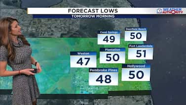
Lows this morning are in the 50s, with wind-chill temperatures in the 40s.

Hundreds of flights were canceled on Monday in South Florida, as a cold front hit several states in the U.S.

As several major Northeast cities brace for a potentially historic snowstorm, travelers are trying to get out ahead of the weather -- including some at Miami International Airport.

Local 10 News Weather Authority meteorologists forecast a dry Valentine’s Day with comfortable temperatures for the South Florida romantics who like the outdoors.

The South Florida Water Management District, the government agency that manages water resources in 16 counties, met on Thursday in West Palm Beach.

Hazy and foggy conditions are expected across parts of South Florida on Thursday as a brush fire in northwestern Broward County combines with shifting winds to reduce visibility in some areas.
When temperatures dropped so low in Florida that cold-stunned green iguanas were falling from trees, state animal regulators moved quickly.

Tuesday morning marked another chilly start to the day, but temperatures will be rising in the afternoon.

South Florida only hit the 50s for highs on Monday and cities across the state, including Fort Lauderdale, set record lows.

Many visitors expecting to get South Florida’s warm sunshine instead had to don heavy jackets as the area experienced a cold snap.

Farmers in southern Miami-Dade County’s Homestead area reported on Monday that the Florida freeze had damaged some crops.
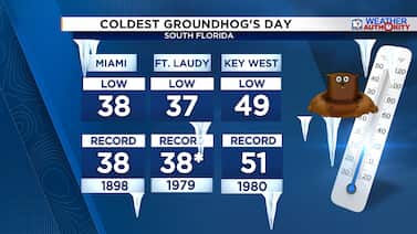
Every Feb. 2, Punxsutawney Phil emerges to predict whether winter will stick around or spring will arrive early.

Students across South Florida braved the cold weather Monday as they headed back to school with temperatures dipping back into the 30s.

With the rare artic cold front in full effect in South Florida, it’s another night of bundling up to keep warm.

As temperatures dropped across South Florida, staff at Flamingo Gardens shifted into cold-weather mode to keep their animals warm.

South Florida was in the midst of its deepest cold snap in more than a decade on Sunday morning, with temperatures in the mid-30s and wind chills in the mid-20s.

Ahead of the cold snap, volunteers with The Homeless Voice rolled up to the downtown Fort Lauderdale bus station with an ambulance packed full of supplies, ready to help people living on the streets.

With a cold snap hitting South Florida, this plant nursery owner is doing everything he can to protect his tropical plants.

South Florida nurseries are rushing to protect their plants as a rare cold snap threatens temperatures not seen since 2010, when significant cold damage devastated inventory across the region.

The powerful Arctic cold front crossed into South Florida early Saturday afternoon, bringing in wind gusts around 40 mph.

An arctic cold front is crossing South Florida on Saturday, bringing rain, gusty winds and a sharp drop in temperatures, with a cold weather advisory in effect for much of the region and freeze warnings posted for inland areas.

We don’t talk about it often in South Florida, but this week, the wind chill number has become the most important part of the forecast.
South Florida is bracing for an unusual cold snap this weekend, and locals and tourists alike are preparing for temperatures far below the region’s typical warmth.

Camillus House activated its emergency housing for people experiencing homelessness Friday in downtown Miami ahead of the weekend’s cold snap.

Cloudy skies and scattered showers are expected Friday as a weak disturbance moves across South Florida, with the best chance for rain across the Florida Keys and East Coast metros.

South Florida is about to feel more like the Midwest this weekend, and Local 10 News wants to see how you’re experiencing the chill.

South Florida is bracing for an unusually cold weekend as Arctic air sweeps into the region, leaving locals bundling up and farmers racing to protect crops.

Cold air that has been building in the Arctic Circle earlier this week is crossing into the U.S. from Canada
Now that the cold front has cleared, we are waking up to a chilly change with lows in the 50s and wind chill temperatures in the 40s.

Bundle up, South Florida! Temperatures are forecast to drop significantly on Monday night as a cold front moves into the area.

The wave of cancellations continued Monday at Miami International Airport as a monster winter storm moving across the country caused chaos at many of the nation’s airports.

Flight delays and cancellations are affecting travelers in South Florida who are heading anywhere on the East Coast this weekend, where winter weather warnings are taking effect.

A sudden cool snap in South Florida has residents debating whether they prefer the region’s signature heat or a brief taste of colder weather.

A Cold Weather Advisory has been lifted for inland Broward and Miami-Dade after the coldest air to hit South Florida in nearly four years arrived.

A strong cold front is moving through South Florida, bringing the coldest air the region has experienced in nearly four years.

Happy New Year’s Eve! It’s a chilly start on Wednesday morning, with temperatures in the 40s.
A cold front is sliding past our area on Tuesday, and behind it, noticeably cooler and much drier air will settle into South Florida.
After all the running around this holiday season, we get a chance to decompress with fantastic weather this weekend!

The Carnival Horizon, a massive cruise ship, set sail this week on a mission to deliver 24 pallets of much-needed medical supplies to Jamaica.

A cold front is forecast to lower temperatures to about 68 degrees on Tuesday in South Florida.

Winter weather continues to hamper travelers returning from Thanksgiving destinations, as a new storm system forms in the Mid-South.

The first season in a decade without a U.S. hurricane landfall also featured three Category 5 hurricanes, including Melissa, one of the strongest Atlantic hurricanes on record.

Winter Storm Bellamy was forecast to disrupt post-Thanksgiving travel on Saturday and Sunday.