A coastal flood statement in effect for 2 regions in the area
See the complete list

Tropical Storm Fernand strengthened Sunday over open waters of the central Atlantic, moving well east of Bermuda.

Any Miami resident can download the ISeeChange app for free.

New bunker inside Golden Beach Civic Center could end up being difference between life and death for some.

As Tropical Storm Nicole nears Florida’s east coast, people in Vero Beach are preparing for its affects.
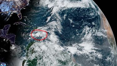
An unusual and impactful late season storm developing north of the Dominican Republic and Puerto Rico – designated Invest 98L – will gradually organize over the next several days and slide westward toward Florida, bringing dangerous seas, widespread coastal flooding and beach erosion, gusty squalls, and the potential for heavy rain to a wide stretch of Florida’s Atlantic coast starting Tuesday into Wednesday.
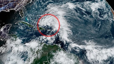
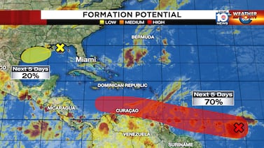
The disturbance moving through the central Caribbean this morning – dubbed Invest 95L – is slowly organizing and will likely become a tropical depression in the next day or two as it heads toward Jamaica, Central America, and the Yucatán Peninsula this week.

Hurricane Roslyn continued to strengthen yesterday as expected, with Hurricane Hunter aircraft finding winds of 130 mph during their afternoon mission while the storm was located about 150 miles southwest of Puerto Vallarta, Mexico.

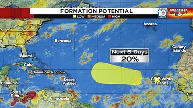
After a busy start to September – especially after two months without any storm activity – the Atlantic is once again cooling off, with only one disturbance we’ll be following this week in the far eastern Atlantic.

Despite continued struggles against wind shear over the past 24 hours, Tropical Storm Earl appears to be gathering steam as it begins its anticipated turn northward some 100 miles north of Puerto Rico and the U.S. Virgin Islands this morning.

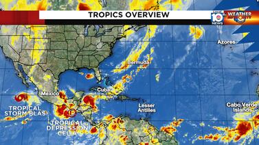
It’s looking a lot like late August out across the Atlantic today – with four areas being highlighted for potential development by the National Hurricane Center – but the broad low pressure area moving into the central Atlantic will be the main story this week.

It’s been thirty years since Hurricane Andrew made landfall, shocking South Florida with the devastation left behind.
Potential Tropical Cyclone Four over the western Gulf moved ashore shortly after sunset yesterday with little fanfare.

The disturbance over the northern Gulf spawned late last week by the leftovers of an old frontal boundary is moving inland over south Texas this morning between Brownsville along the U.S./Mexico border and Corpus Christi.

South Florida’s hot in July. Tell us something we don’t already know, especially this July, one of the warmer ones of the past 25 years.

A disturbance off the coast of Africa may organize into a tropical depression by middle week, becoming the first tropical system in the Atlantic since July 3 and kicking off what is traditionally the busiest stretch of the Atlantic hurricane season.
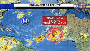
A robust tropical wave – a ripple in atmospheric winds 5,000 to 10,000 feet up triggering a large area of showers and thunderstorms – is emerging today off the coast of Africa.

The summer vacation the Atlantic’s taken for much of July has been a welcome sight, but there are signs the vacation may be coming to an end as we close out the month.

As quickly as Tropical Storm Colin spun up Friday and Saturday over South Carolina, Colin unraveled by early this morning over eastern North Carolina.
We continue to monitor two areas for potential development in the tropics this morning, but neither is a concern for South Florida at this time.
After a spate of storminess for the first half of June, the tropical Atlantic looks to be quieting down, at least for the near term. Disruptive wind shear across the preferred June formation areas of the southern Gulf of Mexico and Caribbean will keep organized activity at bay this week.

As mid-June draws near, there is a “hush” over the Atlantic basin, in part due to the presence of the Saharan Air Layer or SAL.

The strong low-pressure system in the middle of the Atlantic has broken free of the fronts that were attached to it, so it meets the criteria to become a named system.

Hurricane season is still hanging on.

The last few years when October was so slow, an El Niño was underway.

The National Hurricane Center is giving the disturbance off the Southeast coast a decent chance of developing into a tropical depression or storm for a hot minute over the weekend.
The National Hurricane Center is making note of a broad area of disturbed weather over the southern Bahamas.

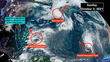
Still-powerful Hurricane Sam finally started to weaken overnight as it slipped past Bermuda about 200 miles to the east.

Hurricane Sam is a classic, super-intense hurricane. Thankfully, it will clearly turn north well away from the Caribbean islands and well east of Florida and the Bahamas. Bermuda will have to watch it as the storm approaches that island toward the end of the week.
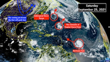
Confidence is now high that Hurricane Sam will avoid the Caribbean islands as the storm arcs off to the north.

Tropical Storm Odette finally formed off the Mid-Atlantic coast yesterday.

Tropical Disturbance #1 is trying to consolidate in the extreme southern Gulf of Mexico. The
The weak disturbance that started in the Caribbean is over Mexico’s Yucatán Peninsula and forecast to drift into the Gulf of Mexico by late today.
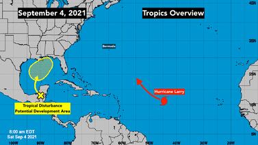
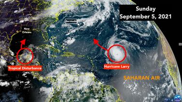
Hurricane Larry is on a path to be a large and very strong hurricane in the tropical Atlantic between the Caribbean islands and Africa.

The animals came from four shelters in southern Louisiana that are at risk of being damaged due to the storm, so staff members reached out to the folks at the Humane Society of Broward County for help.

Hurricane Ida is expected to continue strengthening as it moves across warm water in the Gulf of Mexico and toward the Gulf Coast.

Its projected path has Hurricane Ida making landfall near New Orleans Sunday night, and for that reason, residents have been busy preparing as best they can.

The ingredients are coming together for Hurricane Ida to strengthen and grow larger before it plows into southern Louisiana tomorrow – 16 years to the day after Katrina made landfall on the eastern edge of the state.
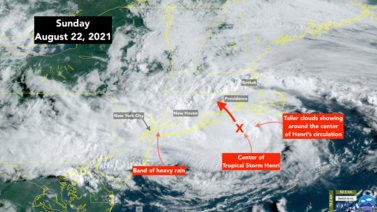
After threatening to wobble west toward central Long Island, Henri has drifted slightly east.

Saturday and Saturday evening are all that left to get everybody to a safe place before dangerous weather from Henri arrives on Long Island and across southern New England overnight.

Disorganized Tropical Storm Grace is speeding west just south Puerto Rico.

The large area of disturbed weather across the tropical Atlantic just south of the Saharan dust plume has three distinct circulations embedded in it.

The Tropical Disturbance we have been following is a large swirl of clouds off the east coast of Florida.

The Tropical Disturbance we have been following offshore of Central Florida has a well-defined circulation with strong thunderstorms on the south and east side.

Local 10 News' Roy Ramos traveled up to Cedar Key, which is near the big bend of the state, located about an hour southwest of Gainesville.

South Florida is in the cone of concern as a new system has strengthened and is now Tropical Depression Five.

There are three disturbances in the Atlantic plus Hurricane Enrique in the Pacific to watch today.

The large tropical disturbance that moved off the coast of Africa this week is slowly progressing across the eastern tropical Atlantic.

After a powerful hurricane left devastating damage to Miami’s historic Vizcaya Museum and Gardens, the historic estate has unveiled a flood mitigation system they hope will prevent any future water damage.

The remnants of Tropical Storm Fay are speeding out of the Northeast and into Canada today.

Tropical disturbances are moving across the Atlantic on schedule, but the atmospheric conditions in the tropics are not conducive from them to develop, as is generally the case in June.

The center of Tropical Storm Cristobal will make landfall on the Louisiana coast later today or tonight.

Tropical Storm Cristobal is on the move, on a due north track.

A complex weather pattern has developed over Central America and the surrounding waters.

Tropical Storm Arthur formed more or less on schedule last night off the Florida coast.


