The U.S. National Hurricane Center warned Monday that Hurricane Melissa could cause catastrophic flash flooding and numerous landslides in parts of Jamaica, Cuba and Hispaniola.
Global Empowerment Mission is one of several organizations that jumps into action when a natural disaster is on the way.
Melissa wasted no time harvesting a rich reservoir of warm water in the central Caribbean south of Jamaica on Saturday to intensify at an extreme rate – from a 70 mph tropical storm Saturday morning to a 140 mph Category 4 hurricane before sunrise Sunday.
Parts of the Caribbean are bracing for Tropical Storm Melissa.
Communities along Florida's big bend have been left severely damaged from powerful Hurricane Helene.
Florida residents in the direct path of Hurricane Helene are preparing for impact.
The effects of Hurricane Helene could be felt in the lower Florida Keys on Wednesday night into Thursday morning.
Tropical Storm Helene is expected to strengthen into the strongest hurricane to make landfall in the United States in over a year sometime in the next 24 hours.
In the calm before the storm, many people in the Tampa area said they are still optimistic.
Tropical Depression 10 has strengthened along the east coast of the Yucatan Peninsula and is now Tropical Storm Idalia.
As Tropical Storm Nicole nears Florida’s east coast, people in Vero Beach are preparing for its affects.
An unusual and impactful late season storm developing north of the Dominican Republic and Puerto Rico – designated Invest 98L – will gradually organize over the next several days and slide westward toward Florida, bringing dangerous seas, widespread coastal flooding and beach erosion, gusty squalls, and the potential for heavy rain to a wide stretch of Florida’s Atlantic coast starting Tuesday into Wednesday.
The disturbance moving through the central Caribbean this morning – dubbed Invest 95L – is slowly organizing and will likely become a tropical depression in the next day or two as it heads toward Jamaica, Central America, and the Yucatán Peninsula this week.
Hurricane Roslyn continued to strengthen yesterday as expected, with Hurricane Hunter aircraft finding winds of 130 mph during their afternoon mission while the storm was located about 150 miles southwest of Puerto Vallarta, Mexico.
Fall is not only enjoyable in South Florida as it sees the humidity begin to break, but it is also when the tropics begin shutting down and the threat from hurricanes gets lower and lower.
Similar to Bonnie back in June, Julia found its footing shortly before making landfall across Central America during the overnight hours as an 85 mph Category 1 hurricane.
Once Hurricane Ian’s leftovers are spread out over the mid-Atlantic this morning, making for a dreary and windy day from the Shenandoah Valley to the Jersey and Delaware coasts, where coastal flood advisories are in place into Monday for low-lying roads and coastal communities
Florida Gov. Ron DeSantis held a press conference Sunday morning as the state continues preparing for Tropical Storm Ian.
Saturday’s forecasts signaled a trend northward in Ian’s potential U.S. strike area, decreasing the odds of a direct run-in with southeast Florida, but placing areas from southwest Florida to the Florida panhandle on high alert for what’s forecast to be a very powerful and impactful hurricane this week.
Fiona continued to steadily strengthen overnight, with its winds approaching hurricane strength (75 mph or stronger) this morning as its formative eyewall begins to scrape the southern reaches of Puerto Rico.
After a busy start to September – especially after two months without any storm activity – the Atlantic is once again cooling off, with only one disturbance we’ll be following this week in the far eastern Atlantic.
Despite continued struggles against wind shear over the past 24 hours, Tropical Storm Earl appears to be gathering steam as it begins its anticipated turn northward some 100 miles north of Puerto Rico and the U.S. Virgin Islands this morning.
It’s looking a lot like late August out across the Atlantic today – with four areas being highlighted for potential development by the National Hurricane Center – but the broad low pressure area moving into the central Atlantic will be the main story this week.
Potential Tropical Cyclone Four over the western Gulf moved ashore shortly after sunset yesterday with little fanfare.
The disturbance over the northern Gulf spawned late last week by the leftovers of an old frontal boundary is moving inland over south Texas this morning between Brownsville along the U.S./Mexico border and Corpus Christi.
South Florida’s hot in July. Tell us something we don’t already know, especially this July, one of the warmer ones of the past 25 years.
A disturbance off the coast of Africa may organize into a tropical depression by middle week, becoming the first tropical system in the Atlantic since July 3 and kicking off what is traditionally the busiest stretch of the Atlantic hurricane season.
A robust tropical wave – a ripple in atmospheric winds 5,000 to 10,000 feet up triggering a large area of showers and thunderstorms – is emerging today off the coast of Africa.
The summer vacation the Atlantic’s taken for much of July has been a welcome sight, but there are signs the vacation may be coming to an end as we close out the month.
As quickly as Tropical Storm Colin spun up Friday and Saturday over South Carolina, Colin unraveled by early this morning over eastern North Carolina.
We continue to monitor two areas for potential development in the tropics this morning, but neither is a concern for South Florida at this time.
After a spate of storminess for the first half of June, the tropical Atlantic looks to be quieting down, at least for the near term. Disruptive wind shear across the preferred June formation areas of the southern Gulf of Mexico and Caribbean will keep organized activity at bay this week.
The most widespread Saharan dust outbreak of the year across the tropical Atlantic is spreading into the western Caribbean, on its way to the Gulf of Mexico and parts of South Florida this week.
As mid-June draws near, there is a “hush” over the Atlantic basin, in part due to the presence of the Saharan Air Layer or SAL.
Miami-Dade and Broward residents are cleaning up after over a foot of rain fell in parts of South Florida.
Tropical Storm Wanda has officially died.
The strong low-pressure system in the middle of the Atlantic has broken free of the fronts that were attached to it, so it meets the criteria to become a named system.
Hurricane season is still hanging on.
The last few years when October was so slow, an El Niño was underway.
The short answer is…maybe, but probably not.
The National Hurricane Center is giving the disturbance off the Southeast coast a decent chance of developing into a tropical depression or storm for a hot minute over the weekend.
The National Hurricane Center is making note of a broad area of disturbed weather over the southern Bahamas.
Still-powerful Hurricane Sam finally started to weaken overnight as it slipped past Bermuda about 200 miles to the east.
Hurricane Sam is a classic, super-intense hurricane. Thankfully, it will clearly turn north well away from the Caribbean islands and well east of Florida and the Bahamas. Bermuda will have to watch it as the storm approaches that island toward the end of the week.
Confidence is now high that Hurricane Sam will avoid the Caribbean islands as the storm arcs off to the north.
Tropical Storm Odette finally formed off the Mid-Atlantic coast yesterday.
Tropical Disturbance #1 is trying to consolidate in the extreme southern Gulf of Mexico. The
The weak disturbance that started in the Caribbean is over Mexico’s Yucatán Peninsula and forecast to drift into the Gulf of Mexico by late today.
Hurricane Larry is on a path to be a large and very strong hurricane in the tropical Atlantic between the Caribbean islands and Africa.
The animals came from four shelters in southern Louisiana that are at risk of being damaged due to the storm, so staff members reached out to the folks at the Humane Society of Broward County for help.
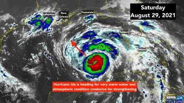
Hurricane Ida is expected to continue strengthening as it moves across warm water in the Gulf of Mexico and toward the Gulf Coast.
Its projected path has Hurricane Ida making landfall near New Orleans Sunday night, and for that reason, residents have been busy preparing as best they can.
The ingredients are coming together for Hurricane Ida to strengthen and grow larger before it plows into southern Louisiana tomorrow – 16 years to the day after Katrina made landfall on the eastern edge of the state.
After threatening to wobble west toward central Long Island, Henri has drifted slightly east.
Saturday and Saturday evening are all that left to get everybody to a safe place before dangerous weather from Henri arrives on Long Island and across southern New England overnight.
Disorganized Tropical Storm Grace is speeding west just south Puerto Rico.
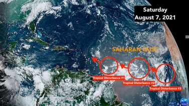
The National Hurricane Center is continuing to call out three systems spread out across the tropical Atlantic.
The large area of disturbed weather across the tropical Atlantic just south of the Saharan dust plume has three distinct circulations embedded in it.
The Tropical Disturbance we have been following is a large swirl of clouds off the east coast of Florida.
The Tropical Disturbance we have been following offshore of Central Florida has a well-defined circulation with strong thunderstorms on the south and east side.
Local 10 News' Roy Ramos traveled up to Cedar Key, which is near the big bend of the state, located about an hour southwest of Gainesville.
Many locals in Key West aren't overly concerned about Tropical Storm Elsa, though officials are urging them to be cautious.
The track of the storm has made a jog because the center reformed behind where it was. Sometimes that’s bad news because it’s a way the system can get better organized and intensify. But in this case, the slightly revised track has taken it closer to Jamaica, which means the circulation is being disrupted by the mountains on that island. The medium-high terrain of eastern Cuba also appears to be ahead of it.
Hurricane Elsa continues to fly through the Caribbean on its way to the waters south of Haiti and eastern Cuba.
South Florida is in the cone of concern as a new system has strengthened and is now Tropical Depression Five.